Down Sound Cruising
Text and Photographs by Paul Clayton
The gentle breezes of May beckoned, and I arrived in Edenton prepared to run down the Albemarle, explore the upper reaches of the Pamlico and loop back up the Pungo and Alligator Rivers. But this is 2022, there have been no gentle breezes. With a forecast of 15-20 knot winds and gusts to 25 on the lower Albemarle, prudence led me to tie a reef in the main and leave the working jib on the furler, rather than swap it out for the genoa. I would be undersailed for the first part of the day, but so be it. With a full 20 gallon tank of diesel, enough to motor 40 hours, I figured the Beta would give the sails some help. Then, as the wind came up, I could fly down to Manteo and be on the dock by sundown.
As departure time drew nearer, the forecast got more interesting. Sometime in the afternoon a front would pass through, and it might bring severe thunderstorms. I kept that in the back of my head.
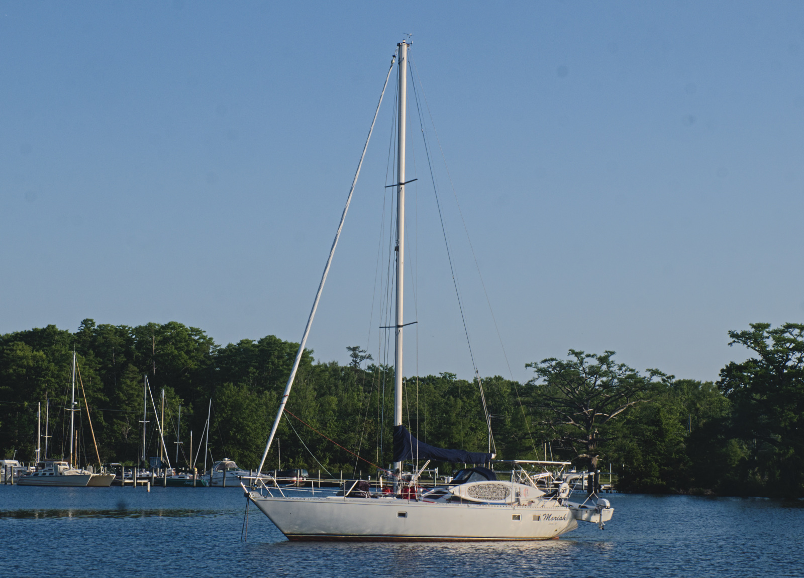 |
I got off the dock at Edenton Marina at 7:20 and motored down Pembroke Creek. Pilot Dan's old boat Moriah was anchored off the channel. After Dan died, his daughter, a traveling nurse, lived aboard Moriah for a while, working at the local hospital. Then she sailed away, perhaps for a different job in a different port. I don't know if anyone is living aboard the boat now or if it is just laid up in the creek. Either way, it was good to see the old boat.
Out in the bay I set sail, shut down the engine and found just enough west in the southerly wind to lay a course for the channel under the power lines. I ended up having to take a couple of short tacks at the end, sailing Terry Ann like a dinghy with the tiller in one hand and the jib sheet in the other.
It was a long broad reach down the sound. I soon found that, with the reefed main and working jib, engine assistance would be needed if I was going to reach Manteo at a reasonable hour.
Last time I sailed Terry Ann, I spent a few hours beating into heavy seas and got home with a bilge full of water. Sitting at dock, the boat made next to no water, but clearly some seam was working when the boat was moving - probably the hull-deck joint. I decided to make a point of stopping every couple of hours to check and pump the bilge, look over the engine, check the battery charge, and so forth. The first couple of times there was negligible water in the bilge, and I got complacent, letting it go for several hours. When I finally did check it, I was alarmed to find the bilge full. I pumped it down and left a hatch cover in the cabin sole open so I could keep an eye on it, but the boat never made any appreciable water after that.
As I passed Bull's Bay I considered turning in and anchoring overnight on the Scuppernong River, but it was too early to call it a day and I continued down the sound. A plague of biting flies infested the boat and pestered me for the rest of the day. In fact, I was still killing them in the cabin the next day.
Early afternoon the clouds started building on the western horizon. By 2:00 they had developed into a huge boiling gray mass. I pushed in close to the banks west of the mouth of the Alligator River, where I would have some windward land cover, and got the boat ready. First I rolled in the jib, then dropped the main and thoroughly tied it down. I left some slack in the mainsheet, and the tiller free. When the first blast hit (the wind went from 10 to 30 knots or more in a second), the boat turned broadside to the wind, the boom swung out to lee, and the boat heeled, but not close to rail-down. It sat there docily, just slowly fore-reaching. I watched for a minute, glanced at the anemometer which was reading 37.5 knots, and went below. There I could watch the chart plotter and see the boat moving north and east at about a half a knot. There was nothing but open water that way. The motion was so easy that I made a cup of coffee while I watched the lightning and waited for the storm to pass. This technique of taking down all sail and letting the boat control itself is known as lying ahull, and has long been used by bluewater sailors to weather storms.
 |
With that over, I started motoring east. The weather was still threatening, so I left the sails stowed. After a while I rolled out some jib, which may have given me a few tenths more knots. By the time I got to a point in front of the old Croatan Sound Bridge, a massive storm was in progress to the south, with violent cloud to ground and cloud to cloud lightning. It was a little too close for comfort, so I rolled in the jib, lay ahull and holed up in the cabin. The weather radio reported a destructive storm savaging the Pamlico Sound, Rodanthe and Avon, moving east at 35 miles per hour. In a few minutes it moved out to sea, and I resumed trekking toward Manteo, though the lightning flashes played on the horizon until late that night.
By this time it was getting late, and I resigned myself to entering Roanoke Sound and Shallowbag Bay after dark. When I reached the big 15 foot flashing red "36" that marks the north end of the Roanoke Sound Channel, I brought the laptop chart plotter and the Dorcy spotlight on deck. I throttled back and began inching my way south along the narrow channel, watching the plotter and depth gauge while every few seconds spotting the next marker with the Dorcy. After a nerve-wracking half hour I reached the 15 foot flasher "30A" at the Shallowbag Bay channel junction. It is vital to pass the little can buoy "29C" before making a square entrance to Shallowbag Bay channel. I didn't spot it until it was right under my bow, but rounded it and passed between "2" and "3", then past the little floating "4". Here I got caught by a gust and set down on the sand, but after a few minutes managed to back off. The next marker, "5", I never saw, but flashing "6" and "8" were clearly visible. I stayed on the high side of the channel and found plenty of water all the way in to the Manteo town dock. As I approached it, I told myself "it's late, you are tired, focus and be careful", and made a perfect approach to the dock, laying the boat on the nicely padded pilings as pretty as you please, 61 miles in 15 hours after casting off from Edenton Marina.
The paddings are new, and much appreciated. The Manteo free town dock is wide open to the prevailing southerly winds which means boats tied alongside are generally griped up hard. So plan on using all your fenders. Boats are allowed 24 hours free docking, but the dockmaster will almost always extend that by a day if you ask nicely. First thing in the morning, I contacted the dockmaster, explained that I had arrived late the previous night, and asked nicely if I could stay an extra day. Permission granted. The town of Manteo provides free WiFi for the whole waterfront area, though it's kind of weak out at the dock. I found that walking to a nearby picnic table increased reception considerably, and I was able to send some emails and peruse the local weather and news.
For sailors who need shorepower, there is a commercial marina at the waterfront. Restaurants and gift shops abound in the area, all the usual things to separate tourists and their money. There is also a small boat museum. Unfortunately, sailor necessities like beer and ice require a walk out to the main drag.
Manteo has made the transition from fishing village to tourist town with more grace than a lot of places. While the boatyards and wetlands are mostly now replaced with many thousands of vacation rentals, there are no high rises and none of the tawdry glitz that marks too many tourist towns.
Where to next? I was at the lower end of Albemarle Sound and had options. South down Roanoke Sound and Old House Channel would put me in Pamlico Sound, and I dearly wanted to explore Long Shoal River. The weather forecast for Wednesday was northerly breezes coming around to east, which would be fine, but after that, the wind was forecast to shift to southwest and blow from that direction for days. That would bottle me up in the upper Pamlico with only one way out - back to Manteo.
I could sail to Elizabeth City. It seems counterintuitive, but look at a chart and you will see that Elizabeth City is as much west of Manteo as north. Northerlies trending toward easterlies would be a fair wind for Elizabeth City.
Another option - sail northwest and turn in North River, the ICW route through Coinjock, and check out one of the Claiborne Young recommended anchorages along that route.
What won out, though, was sailing diagonally up across the sound to the seldom-visited Little River, that flows south from Nixonton in Pasquotank County into the Albemarle Sound, west of the Pasquotank River and east of the Perquimans. I don't know anybody who has sailed into the Little River - why shouldn't I? One of my goals for this trip was to visit somewhere new to me.
 |
Off the Manteo dock at 8:20 Wednesday morning. I motored out the channels to red "36", raised the reefed main and working jib, shut down the engine and sailed smartly along the northern shore of Roanoke Island. Alas, the winds faded and it seemed like an inordinate amount of time before the Mann's Harbor Bridge disappeared astern. At 2:55 in the afternoon I decided that a motor assist was required if we were to make anchorage in Little River before nightfall. A couple of hours later we approached the northern shore of the sound, a bit east of the mouth of Little River, due to me favoring the starboard to keep a little wind in the sails so they wouldn't slat. I dropped sail and motored back west, then in the mouth of the river. Claiborne Young in his guidebook gives extensive instructions on entering the twisting channel, but in truth with a chart plotter it is a simple matter. I found a broad, attractive stream with a mix of houses, forested banks and one agricultural processing plant. It looked to be a good anchorage in anything except southeast winds, which had free rein to blow straight up the river.
Southeast winds were just what we had. I considered anchoring along the east bank which would give some shelter, but the forecast was for the winds to shift to southwest and blow hard after midnight. I decided to accept anchoring on a lee shore with 10-12 knot airs gusting to 15, with the probability of being on a windward shore with 15-20 knot winds gusting to 25 later on.
I edged in toward shore until we were in about 8 feet of water, circled and dropped the anchor. I got a suspiciously fast hookup and the thought crossed my mind that we were snagged on something. On the other hand, Fortresses are good about fast hookups. I continued with the anchoring process, veering out line and letting the boat drift back. Eventually I had about 60 feet out, plenty of scope, and everything seemed solid.
It was getting late but my plan was to stay up until the wind shifted around to southwest. I had some supper, finally, and settled back, reading and getting up to check the shoreline every 15 minutes or so. As it got later and everything seemed good, I took a couple of short naps. By midnight, the winds had shifted, the chop had gone down since the fetch was masked by the windward shoreline. It blew hard later, but the boat lay quietly on the flat water.
In the morning I tried putting up the reefed main but the boat sailed around on the anchor, getting sideways and heeling, so I took it back down. The wind was blowing hard enough that I had to motor up on the anchor, and when I got short on the cable I found that yes, I was snagged on something. After 15 minutes of working and circling, I finally got the right angle to pull it free. In the sheltered water of the river, I set the main and jib, and motorsailed out the channel, shutting down the engine at the mouth.
The winds declined, and I should have taken out the reef early on, but I carried it until the turn into the Pasquotank. With the flat, sheltered water of the river, I felt confident about carrying more sail, even if the winds came up. As I turned up to the northwest and got the wind more on the beam, the boat took off, and I had a very nice sail for a couple of hours. Gradually the wind veered until it was pretty much straight down the river, and I had to drop sail and motor the last couple of hours.
I was a little concerned to see only one boat on Mariners Wharf. Usually by late May the snowbirds are coming through, and the dock is crowded. Later a big catamaran came through, hailing out of New Bedford, but that was it for the night. I had seen a couple of northbounders ahead of me earlier in the day, and when I thought about it, more people may be docking at Mid-Atlantic Christian to avoid having to wait for the bridge to open during morning rush hour. Another reason people might be avoiding Mariners Wharf this weekend was the Potato Festival. Already on Thursday afternoon crews were setting up for this enormous local shindig, and the waterfront was going to be the center of it.
One nice new feature at Mariners Wharf is free WiFi. Between the library, several local pubs and restaurants, and the waterfront, finding a connection is getting to be easy.
Later a big catamaran docked but that was it for transients. Oh yes, a pontoon boat pulled up with a couple and two kids, on its maiden voyage for new owners, to scope out the Potato Festival in advance of coming up the next day to enjoy it in its full freaking grandeur. From Camden, of course. It seems that some Camden people boat up to Elizabeth City rather than drive. I remember a few years ago standing on Mariners Wharf long after dark and seeing lights coming up the river. It turned out to be a young couple motoring up from Camden to see friends in a band playing at a local bar. For those who boat up from Camden, we salute you.
 |
Friday morning when they set up a portable head in the parking lot directly in front of my boat, I decided to decamp for the Mid-Atlantic Christian University dock, just upstream of the Hwy 158 bridge. The bridge tender monitors 13, and I contacted him to get an opening schedule - it was a few minutes before 9:00, and he told me he would open on demand after 9:00. I got the boat straightened up, the engine running and the docklines in, and passed through the bridge at 9:20. A few minutes later I tied up on the MACU face dock. I had a nice phone conversation with the dockmaster, who was in Florida, and he gave me permission to stay for 48 hours, or longer if I wanted to, and that one of his deputies might stop by later to chat.
The dock at MACU was built in conjunction with the Boating Infrastructure Grant Program of the Fish & Wildlife Service, along with money from the estate of Jack Alan Hardy. The University maintains it and keeps the surrounding property in Bristol fashion. There are a few short slips that are usually occupied by boats of a University partner, Maritime Ministries, and there is a long face dock that will easily accommodate three or four boats. There is water at the dock but no hookups. The beautiful campus lawns come right down to the dock.
My primary goal at this point was to get a shower. I walked back to the Museum of the Albemarle, which is where you pay $5 to get the combination to the waterfront shower. The one payment serves for your entire stay, a great bargain in my book.
Next I stopped by the bakery. Their main business is cakes and confections, but they sometimes bake bread. Not today, though. Too bad, since I was out of bread. Groceries in general were getting low, and ice was just a fond memory. I made a point of finishing perishibles during the day, and planned to throw out what I couldn't eat. I still had potatoes and black-eyed peas. That's what I would eat as long as the propane lasted, then it would be graham crackers and peanut butter.
 |
The convenience store is easily a mile away, and I figured that a bag of ice would be near melted by the time I carried it back in the 95 degree heat. On the other hand, there was a sign on a back door of the Jennette Bros. warehouse next to the college that suggested there was a butcher shop inside. I thought they might sell or give me some ice, so I went in to find a large, gleaming store with coolers full of prime cuts, and a long line of patrons waiting to have their orders filled. When my turn came I asked about ice, and they said no, sorry, they couldn't sell ice, but Coaster's, the pub another block over would probably give me some. So I gave Coaster's a try, and the owner, sitting at the counter drinking with some friends, directed the waitress to fill my sailcloth bag, refusing payment, so I left the girl a tip and walked back to the boat with 10 pounds of clean, glistening ice.
I knew that the ice wouldn't last - the first 10 pounds just starts to get the icebox cold - but it would hold over eggs, cheese and vegetables for another day, and more important, it would cool all the lemonade that my last lemon would make - fortunately, I had plenty of sugar. I spent the afternoon sitting in front of the Hella fan sipping ice cold lemonade. A little vodka might have gotten in there too, who knows?
Keith, a Maritime Ministries staffer, stopped by and we had a pleasant chat. Paloma, his boat, was in one of the slips, and I grilled him at length. It looked like a Westsail 32, but just different enough to make me wonder if it had been heavily modified, or was a prototype. Turns out she is an English-built Colin Archer lifeboat design from 1972, in wood. Probably a Thistle, as several of them were built from plans. The Westsail 32 was adapted by Bill Crealock from the Thistle design.
The heatwave continued, but so did the southerly wind, which made it bearable. Saturday morning I carried the laptop to the library and sat in the cool air-conditioning, reading the shocking news that the Oregon Inlet channel had shoaled in to the point that the Coast Guard was removing the markers, as the marked channel was unnavigable for most vessels. Back at the MACU dock, a couple of cruisers came in, and one stopped for a few minutes to walk the dogs.
The Potato Festival was in full swing, and all day and late into the night the bands played and the children on the carnival rides screamed. A steady procession of runabouts and skiffs ferried festival-goers to the dinghy dock in the heart of it all, some honoring the no-wake zone in front of the college and some not.
Sunday morning after my daily shower I walked to the Colonial and enjoyed eggs, bacon, grits and toast. Back at the boat, I took advantage of the high water to brush down the starboard hull above the water, and below as far as the brush would reach. After days of southerly winds, the water was almost to the top of the dock.
I found Keith aboard Paloma and begged a tour. The boat was built in Kent in 1972, of wood, and is in fine condition. The spacious interior is white with lots of bright mahogany trim. Power is supplied by a 57 hp Yanmar. There is a huge forepeak with space for a double bed, but low headroom, then to aft port a retention head which Keith is replacing with a composter. Across is a hanging locker, then to aft starboard a galley with a refrigerator and water maker. To port is a u-shaped settee usable as a berth, with a table, and to starboard a pilot berth. Under the cockpit is the Yanmar in a large but low compartment. On deck is a small cockpit with a tiller, high bulwarks with huge draining ports, a boomed staysail on a traveler, and a big genoa on the bowsprit.
I walked down to Mariners Wharf and watched local band Permanent Vacation at the bandstand. They were really good, loud punk pop, a great break from the endless Country and Soul bands that had performed Friday and Saturday. Afterward I went in the Kraken, a coffee shop within sight of the waterfront. They sell the usual coffees, smoothies and pastries. Their best features are the comfortable armchairs and sofa, and a long bar with tall chairs and power outlets, perfect for hooking up a laptop. Like most of the local businesses, they provide free WiFi.
 |
Back at the boat, I heard an approaching helicopter, and watched as the Coast Guard flew in and hovered over the water off Mariners Wharf, kicking up spray and mist that drifted over the Potato Festival crowd. It was a warm day and I'm sure very pleasant for all the folks who had spent the day carousing and making merry.
The forecast for Monday was north winds 10-15, veering to east late in the day. That was the chance I had been waiting for, so Sunday night I made preparations for an early start. The bridge opens on demand 24 hours a day except during morning and evening rush hours, when it opens on the half hour. So if I could get on my way before 7:00 AM, I wouldn't have to wait.
Overnight the forecast changed to include probable gusts to 20 knots or more. Since I didn't have a reef in the main, I decided to motorsail with the jib and dispense with the main altogether. I got a very early start, off the dock at 5:35 and through the bridge 10 minutes later. I motored down the river, with no wind at all. After a while a light northeast breeze started, and I rolled out the jib for an extra half a knot. Out on the sound, the wind was almost east, and I was glad not to have the main to deal with, backwinding the jib and threatening to jibe.
Through the day the wind got stronger and blew straight up the sound, east to west. I am coming to the belief that winds on the Albemarle only blow straight up or down, because it seems I am always beating straight into a headwind or running straight off. The winds today increased until we were galloping along at six knots with the stern slewing side to side. Once we turned off into Edenton Bay west of the power lines, with the wind coming over the quarter, the boat was almost out of control, so I shut down the engine and ran up the bay at five knots under working jib alone.
I rolled up the jib at the head of the bay and gingerly motored up Pembroke Creek. Backing into my slip I stirred up a plume of mud and had to gun the engine to get over the hump that seems to have developed immediately in front of my slip. Lines were tied and the engine shut down at about 3:30. Statistics for the day, courtesy of OpenCPN - total nautical miles, 48.62, average speed 5.03 knots, total time 9:40. A good fast trip.
Some thoughts on recent additions to Terry Ann. First, the Panasonic Toughbook with OpenCPN software. I wouldn't have even considered navigating the Roanoke Sound and Shallowbag Bay channels after dark without a chart plotter. The tricky entrance to Little River proved to be no trouble at all with the plotter. A couple of notes regarding OpenCPN. The software allows the user a choice of RNC or ENC charts. The RNC charts are a facsimile of the paper charts that we are all familiar with. Either type is updated on a monthly basis by NOAA and is easily downloaded into the software. There is no charge for the OpenCPN software or the updated charts, so nothing stands in the navigator's way - if he wants the very best, most accurate and up-to-date charts, there is nothing stopping him. I always update to the current month before each trip. Second, The Beta 20 diesel. The engine got plenty of use this trip and performed flawlessly. Along with the chart plotter, it made it possible to enter the Roanoke Sound and Shallowbag Bay channels at night. As much as possible, I follow the operating instructions that Beta recommends, running at three-quarters of maximum rpm of 3500. That means we run at 2700 rpm and burn a consistent half gallon of diesel an hour. John Deaton, the installer, went to great lengths to match the propellor size and pitch to the engine power and boat characteristics, and succeeded beyond my expectations. Terry Ann tracks with almost no helm, and backs beautifully. Most of all, I feel confident that the Beta is going to run reliably.
Text and Photographs by Paul Clayton. Posted 05/28/22.
Copyright © 2022 Paul M. Clayton.