Adding Chart Plotter Capabilities to Your Android Tablet
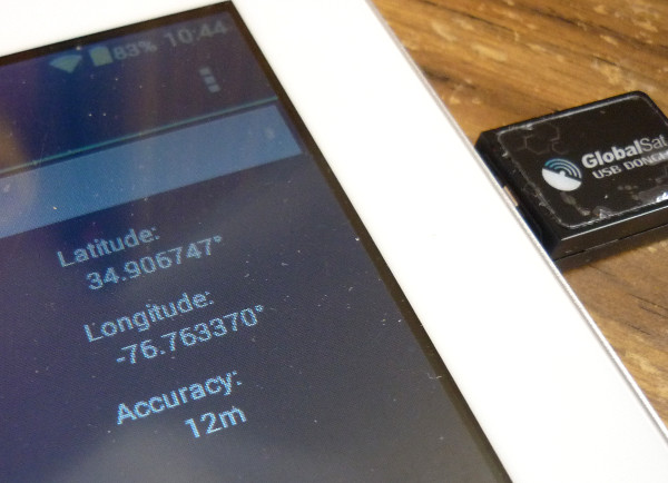
Would you like to add chart plotter capabilities to your Android tablet? It's not hard. First, you need a GPS. If you have a cell phone you can probably piggyback your Android's internal GPS off it, but since I don't I had to buy an external GPS unit. I chose a Globalsat ND-105C which plugs into an OTG USB port on my tablet. It comes with a cable to adapt to a standard USB, in case your tablet doesn't have an OTG port. It costs about $35 at Amazon and is a good quality unit.
 |
Next, you need a good power source. The GPS polls a satellite once a second and the plotter has to redraw the screen, so don't expect to get the advertised life off a battery charge. I bought a car charger for my tablet and a cigarette lighter socket with alligator clips that clamp straight to my 12 volt house battery on the boat. This is more than enough power to run my tablet for days on end. Total cost - about $15.
That's it for hardware. Now you need two pieces of software, both available from Google Play. Since Google has gone to the grand unified theory for sign-ins, you just sign in using your gmail account. The first time you use Google Play, you will have to give them a credit card number which they will store for any book or app purchases. Start off by downloading a free app called You Are Here. This app takes the signal from the GPS and feeds it to the plotter software. Once it is downloaded, go into your Android settings and be sure developer-allow mock locations is checked.
One more thing and your Android will be a chart plotter. Go to Google Play and download a plotter app. There are several, and I chose MX Mariner. Search for it, purchase it ($6.99) and let it install itself on your tablet. Open it and it will ask if you want to install charts - say yes and it will give you options for several chart bundles covering different parts of the coast. You can download as many as you like. MX Mariner will ask where you want to save them and it would probably be smart to save them to a dedicated sd card.
 |
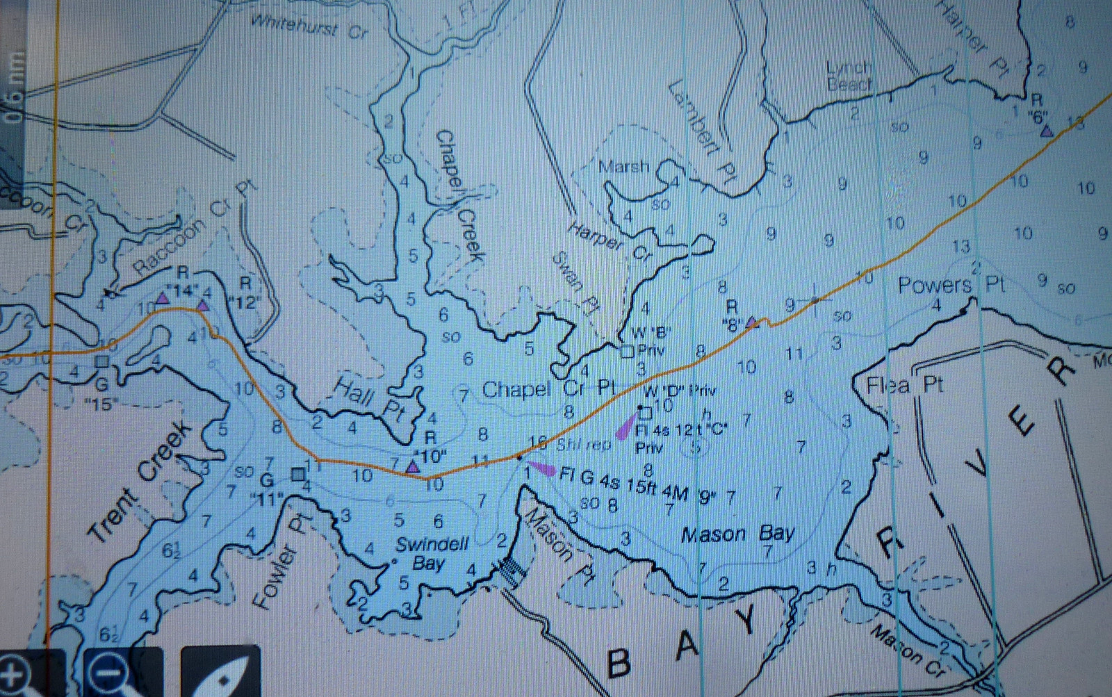
To use your chart plotter, plug in the GPS, then start You Are Here. In a minute or two, the app will show your current location on the right side of the screen and the results of the GPS's satellite polling will scroll down the left side. Then start MX Mariner. The software uses raster charts so the display looks just like a familiar paper chart. Take a few minutes to review the excellent help files and you will be on your way.
So how does it work in real life? Pretty well, all things considered. The GlobalSat GPS has no problem acquiring a satellite signal, and the software does a good job of registering position on the chart. One issue that I haven't been able to resolve - the software can record a track, but occasionally the track shoots off to the equator or the Greenwich Meridian for just a few seconds and then resumes correct plotting. This means the distance travelled and speed records are completely inaccurate. I think this happens when the MX Mariner jumps from one chart to the next, but I guess it could be due to the GPS briefly losing satellite contact. It doesn't effect the usefulness of the app for navigation, just makes for ugly tracks. It's possible to download the .gpx track file and clean it up with a text editor if you need a clean record of your trip. The app developer is actively updating and fixing MX Mariner so maybe this problem will go away in time.
Another consideration - marine chart plotters are built for the marine environment, and most Android tablets are not. The cockpit of Valor can be a wet place even when it is not raining. The deck is hard, unforgiving fiberglass just waiting for a clumsy Neuse River sailor to drop his tablet and crack the screen. Also, standalone chart plotters are built with very bright screens so they can be seen in direct sunlight. Most tablets are not. If I were used to having a chart plotter available for constant reference, I would want a Lowrance, Garmin, Raymarine, or other brand built specifically for the job. However, I usually work from paper charts so I rarely miss having a chart plotter.
 |
So, you might ask, what is an Android tablet chart plotter good for? Well, it makes a good backup in case of catastrophic failure of your primary plotter. It's good for laying out courses at home that can then be uploaded to the plotter on the boat. If you are a paper chart sailor, you can leave it on, below deck, to get an accurate track of your day's sail. And there are a couple of off the beaten path sailing areas near me that are not on any of the charts in my Maptech chart book - the upper part of the Bay River and the far upper reaches of West Bay - but are clearly charted in my MX Mariner software. So I'd say that a tablet chart plotter is just another tool in the navigational box - maybe not necessary, but useful nevertheless.
The MX Mariner software includes digital charts for all U.S. waters, so even if you never used the plotter features, it is a cheap way to get a complete set of charts. You wouldn't even need to buy the hardware components - the GPS and power lead - just the MX Mariner software.
I am very satisfied with this project. It has been a good introduction to chart plotters and a lot of fun. Practically everyone has a tablet now, so why not add chart plotter capabilities?